|
|
|
|
|
|
|
|
|
|
|
|
|
|
|
|
|
|
|
|
 |
|
|
 |
|
|
|
|
|
|
|
|
|
|
| PART IV |
|
| MAGNETIC NORTH |
| THE WANDERING POLE |
|
|
|
|
|
 |
|
|
|
|
|
|
|
|
|
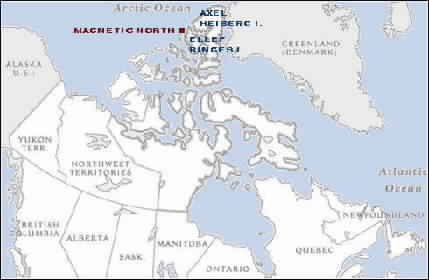
| Maps are based on true, or geographic, north, i.e. the north pole at 90�N. However, magnetic compasses point to Magnetic North, a mineral deposit in the High Canadian Arctic. In lower latitudes, the angular difference between True North and Magnetic North is compensated for by a value known as Magnetic Variation. But to further complicate matters, Magnetic North is not a fixed point on the earth's surface but is constantly on the move; therefore magnetic variation must be recomputed on a regular basis. In the past 100 years, Magnetic North has wandered approximately 600 miles to the north to its present location near Ellef Ringes Island in the Canadian Arctic. |
|
|
|
|
|
|
|
|
|
|
|
|
|
|
|
|
|
|
|
|
|
|
| THE HIGH CANADIAN ARCTIC AND MAGNETIC NORTH |
|
|
|
|
|
|
|
|
|
|
|
|
|
|
|
|
|
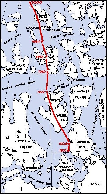
| THE WANDERING POLE 1831 - 2000 |
|
|
|
|
|
|
|
|
|
|
 |
|
|
|
|
|
|
|
|
|
|
|
| Map based on a BC s&r map. |
|
| Sir James Clark Ross first determined the location of the North Magnetic Pole in 1831. Some seventy or so years later, in 1904, Roald Amundsen re-located the pole during the course of his 1903-1905 transit of the Northwest Passage in the sloop Gjoa. Since that time the pole has followed a meandering path northward to its present location near Ellef Ringes Island. |
|
|
|
|
|
|
|
|
|
|
|
|
|
|
|
|
|